
|
|
|
Database of British and Irish hills
Graham Jackson, Chris Crocker, John Barnard, Simon Edwardes, George Gradwell, Jim Bloomer and Dave Marshall
20742 classified hills including Marilyns, Humps, Tumps, Simms, Dodds, Munros and Tops, Corbetts and Tops, Grahams and Tops, Donalds and Tops, Furths, Hewitts, Nuttalls, Buxton & Lewis, Bridges, Murdos, Deweys, Donald Deweys, Highland Fives, Yeamans, Clems, Wainwrights, Birketts, Synges, Fellrangers, Ethels, High Hills of Britain, County Tops, SIBs, Dillons, Arderins, Vandeleur-Lynams, Carns and Binnions, with subs and deletions For background, instructions, and further information on specific hills please consult the Database Notes Current release: v18 29 July 2023 Revision History changes in the current and previous releases
Overcoming security blocks with the Access database See Upgrading when transferring personal ascent records between Excel or csv versions, including records from the former P30 Appendix. Users of the Access version should use the inbuilt facility to import logs from previous versions in Access or Excel. There is also a facility for importing/exporting records to and from www.hill-bagging.co.uk. You can use the Access versions even if you do not have Microscoft Access. Download the free Microsoft 365 Access Runtime (for Office 2019 or 365), Access 2016 runtime, Access 2013 runtime or Access 2010 runtime from the Microsoft website after checking that your version of Windows meets the requirements. Do not install a runtime version of Access if you already have a full version of Access on your computer. The Munros and Tops 1891-2021Graham Jackson and Chris Crockerv8 31 May 2021 Comprehensively overhauled with many more explanatory notes and extracts from old maps. Aligns with v17.1 of the Database of British and Irish Hills with data updated to 30 May 2021. An .xls file (Excel 97-2003) with slightly reduced functionality is available on request. Minor correction (v8.0.1) on 6 June 2021. Right-click and save to download without viewing
The Corbetts 1953-2016v4 8 February 2017 Aligns with v15.3 of the Database of British and Irish Hills. Includes the replacement of Carn Liath by Creag an Dail Bheag in 2015 and the promotion of Cnoc Coinnich in June 2016.
The Donalds 1953-2021v3 28 January 2022 Aligns with v17.3 of the Database of British and Irish Hills. Includes the relocation of Meikle Millyea in Nov 2015 and the reinstatement of Dugland in Feb 2021, both postdating the 2015 SMC Guide. An .xls file (Excel 97-2003) with slightly reduced functionality is available on request.
|
Copyright The Database of British and Irish Hills is licensed under a Creative Commons Attribution 4.0 International Licence. Our preferred method of attribution is to reference The Database of British and Irish Hills v18 (or other version) and link to this site. GPS users - can you help?Our objective is to present a 10-figure grid reference based on site measurements for the true summit of every hill in the database. If you would like to help, please read our requirements in the Database notes. You can also submit measurements on Hill Bagging. Our interest is not limited to hills for which we lack a figure, as multiple measurements improve the accuracy and reliability of the data.DoBIH fund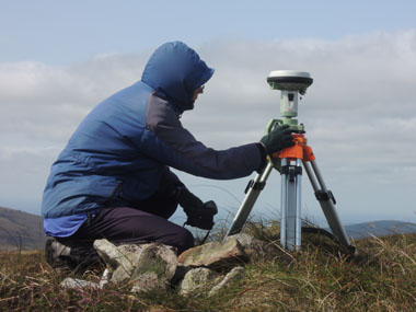
Setting up the Leica GS15 on the summit of Table Mountain
In response to a number of requests, we have provided this PayPal facility for those wishing to contribute towards the development of the database. Most recently the fund has paid for two sets of highly accurate 1:25000 and 1:20000 maps from EastWest Mapping which has significantly improved the quality of our Irish data. Further maps are being purchased as coverage increases. In the past we have used the fund to purchase new equipment for our survey team. A brief summary of their equipment and objectives is given in the Database Notes. Please email if you would prefer to contribute by cheque or bank transfer. We are grateful for all the donations received. DoBIH user surveysOur most recent survey had a considerably expanded scope. It sought to find out how you use the database and the associated Hill Bagging website, what lists you're bagging, your opinions on hill lists and other matters.Editorial review of the Nov 2018 user survey Nov 2018 user survey (Powerpoint) Previous surveysAs we aim to provide lists and features people want, we place considerable value on the feedback we receive from users. Version 12 reflected to a large extent the views expressed in the 2010 survey. FeedbackPlease get in touch if you have any thoughts about the database, or if you find an error. Comments and suggestions are always welcome. |